Surface Water and Ocean Topography (SWOT) satellite.
SWOT successfully lifted off on 16 December 2022, at 5:16 pm Friday IST. The rocket’s payload incorporates advanced microwave radar technology to collect high-definition measurements of water bodies.
It’s the first satellite mission that will observe nearly all water on Earth’s surface. NASA tweeted through its Twitter handle,”We’re ready to start #TrackingWorldWater with the Surface Water and Ocean Topography (SWOT) satellite.”
LIVE: We’re ready to start #TrackingWorldWater with the Surface Water and Ocean Topography (SWOT) satellite. Liftoff is scheduled for 6:46am ET (1146 UTC) from @SLDelta30 in California. https://t.co/ymWf4UswfD
— NASA (@NASA) December 16, 2022
The weather forecast was favorable for the launch. NASA’s launch services team was able to manage the weather conditions for the mission. However, the launch was delayed by a day after technicians detected traces of moisture in two of the rocket’s engines.
Know more
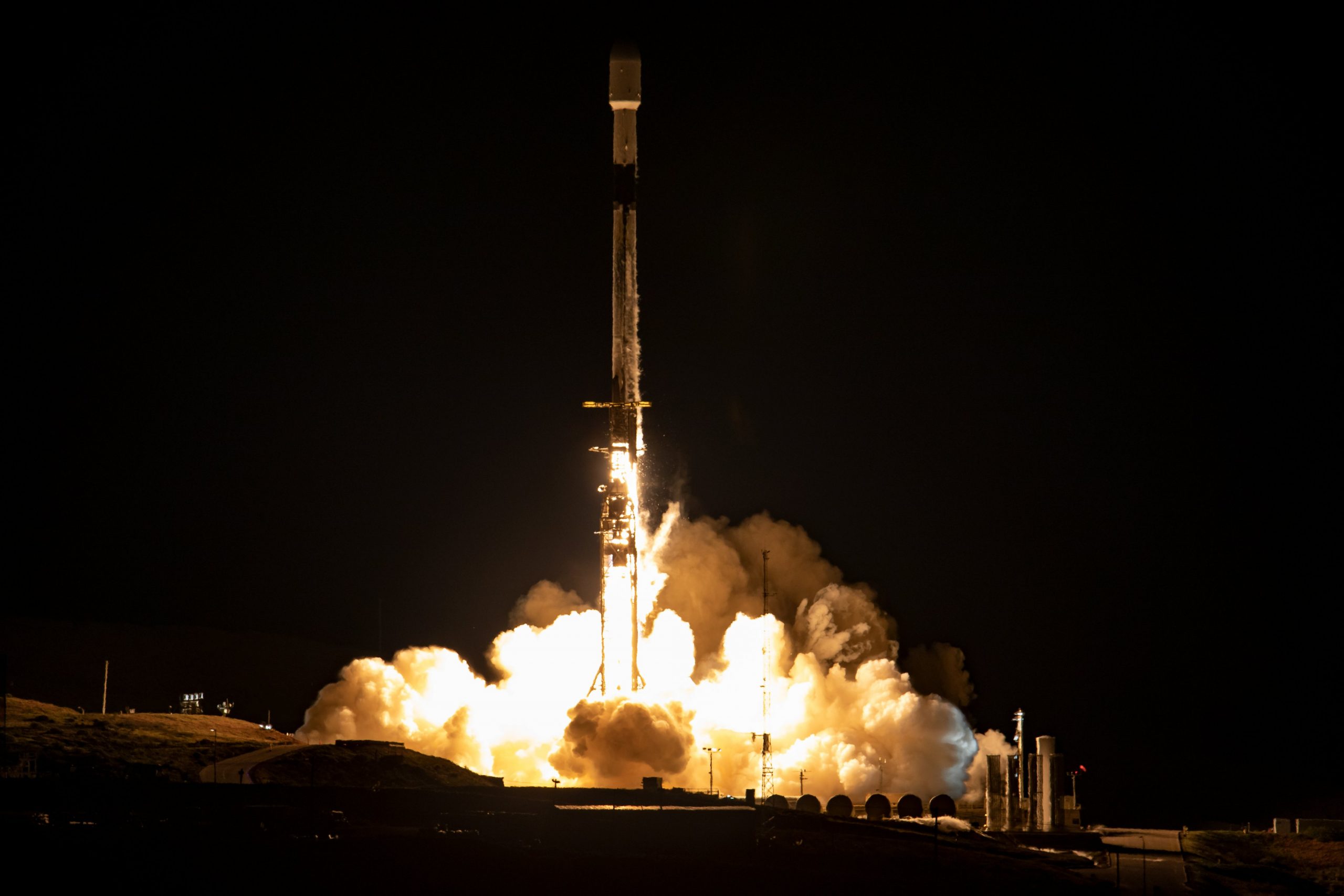
Falcon 9 launches the Surface Water and Ocean Topography (SWOT) mission to orbit. It’s upper stage, carrying the satellite, reached orbit within nine minutes. Moments earlier, the reusable lower stage separated from the rocket and flew itself back to Earth, unleashing sonic booms before slowing to a gentle landing at the base.
Falcon 9’s first stage has landed back on Earth pic.twitter.com/u7LLdetYNZ
— SpaceX (@SpaceX) December 16, 2022
Deployment of SWOT confirmed at 6:40pm IST. First stage booster returns to Earth at 8:30pm IST. The mission’s payload has released to its own starting orbit. Orbit is about 530 miles (850 km) above the planet. It took less than a hour to reach there after launch. Video from a camera mounted on the rocket’s upper stage showed SWOT floating away.
The mission control for the French space agency CNES in Toulouse reported it had recovered the first full set of signals from the satellite, within half an hour. It confirms that SWOT’s systems were operational, NASA said.
The Falcon 9 booster owned and operated by Elon Musk’s commercial rocket company lit up the predawn sky along California’s coast as it roared off its launch pad at the Vandenberg US Space Force Base, about 160 miles (260 km) northwest of Los Angeles.
Also read: SWOT: NASA To Launch
SWOT is to precisely measure fine differences in surface elevations around smaller currents and eddies. SWOT can do so with 10 times greater resolution than existing technologies, according to JPL.
The centerpiece of the satellite is advanced microwave radar technology to collect high-definition measurements of oceans, lakes, reservoirs and rivers over 90% of the globe.
Researchers say,” The data will get compiled from radar sweeps at least twice every 21 days. It will be used to enhance ocean-circulation models, bolster weather and climate forecasts and aid in managing freshwater supplies in drought-stricken regions.”
To read more such news, download Bharat Express news apps